


Have you been dreaming of hiking Laguna 69 but not sure where to begin? You’re not alone. Many travelers feel a bit lost with questions like, “How hard is the hike?” or “What’s the weather like up there?” Planning a trip to this breathtaking turquoise lake can feel tricky, especially when dealing with altitude and timing.
It’s understandable—these are common concerns. Did you know Laguna 69 sits at an incredible 15,092 feet in Huascaran National Park? The high altitude makes it more challenging for hikers.
Need Quick & Easy Trip Planning? We Can Help..


Free Itineraries Based on your Schedule & Budget
Booking Assistance for Hotels, Flights and Transfers
24/7 Customer Support & Personal Travel Advisors
But don’t worry; we’ve done all the homework so that you don’t have to! From how to get there and what gear to pack, to tips for staying safe—we’ve got everything ready for you.
This guide will walk you through each step clearly and simply. Ready to take on one of Peru’s most stunning hikes? Get ready for an unforgettable experience!
Laguna 69 Hiking Table of Contents
Laguna 69 Hiking Key Takeaways
- Laguna 69 is a stunning turquoise lake located at 14,927 feet in Huascarán National Park, Peru. The hike covers 12 km roundtrip with an elevation gain of 800 meters.
- The best time to visit is during the dry season (May–September) for clear skies and safer trails. July has the least rain.
- Altitude sickness can affect hikers due to thin air above 3,000 m; acclimate in Huaraz (10,013 ft) for two days and drink plenty of water.
- Entry to the park costs S/30 ($9) for foreigners; camping near Laguna 69 is not allowed but permitted close to Cebollapampa trailhead.
- Pack essentials like trekking poles, layers, sunscreen, snacks, and at least 3 liters of water to stay prepared for shifting weather conditions.

Overview of Laguna 69

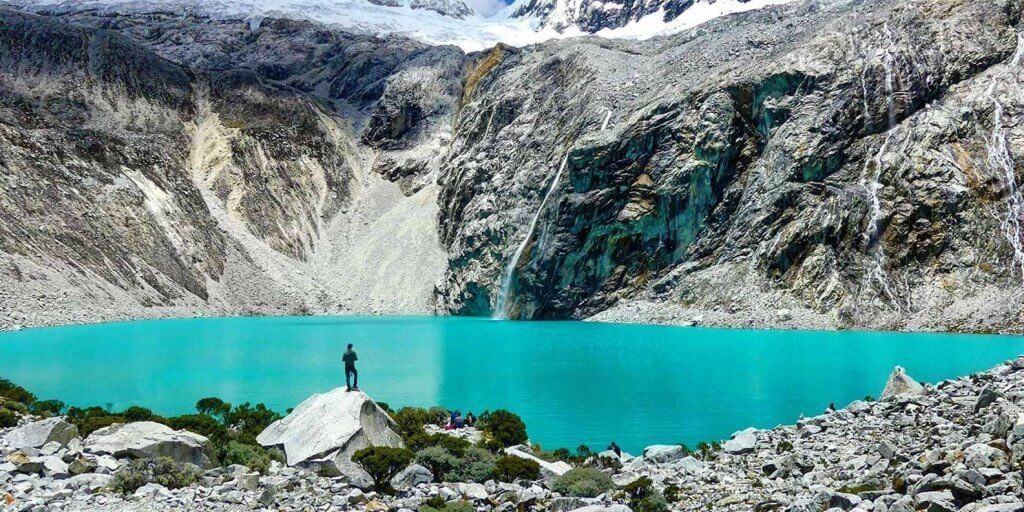
Laguna 69 feels like something out of a dream, hidden high in the Cordillera Blanca of Peru. Its bright turquoise waters, cradled by snow-covered peaks, make it one of the most breathtaking sights on Earth.
Tucked inside Huascarán National Park at an altitude of 14,927 feet (4,550 meters), this lake is not only stunning but also part of a UNESCO Heritage Site.
The name “Laguna 69” might seem unusual at first. It comes from a numbering system used when over 300 lakes were mapped during the park’s creation between 1977 and 1985. This hike isn’t just about walking through beautiful landscapes; it’s surrounded by towering mountains like Huascarán and other striking glacial views.
How to Get to Laguna 69
Getting to Laguna 69 starts with a journey through Peru’s stunning landscapes. We pass bustling cities, winding roads, and towering mountains on the way there.
Traveling from Lima to Huaraz
The route from Lima to Huaraz covers 250 miles, or about 402 kilometers. Buses take around eight hours and are the best way to travel. Cruz del Sur is a popular choice with VIP seats, blankets, headphones, and tickets costing S/75–S/114 ($20–$30).
Other options include Movil and Civa companies.
Most of us pick an overnight bus for convenience since it saves time. The buses all pass through Caraz, which is closer by an hour and a half to Laguna 69 than Huaraz. This makes Caraz another option for travelers who want quicker access later on.
Once in Huaraz city though, we can start acclimating before tackling the high-altitude trek!
Reaching the Trailhead at Cebollapampa
Getting to the trailhead at Cebollapampa, or La Cebolla, is pretty simple. It sits at 3,800 meters (12,467 feet). From Huaraz, we can take a colectivo for S/15–20 one way. These shared rides start early around 5:30 AM and get us there by about 8:30 AM.
A taxi is faster but more expensive at around S/180 ($50) roundtrip.
Public transport works too! Minibuses leave from Huaraz between 5:30 and 6 AM for just S/5. If you’re coming from Caraz first, buses to Yungay cost only S/2 and run as early as 5 AM.
From there, we’d switch transportation to head straight to the parking lot near the trailhead where camping is also allowed nearby—not directly on-site though!
“A little planning goes a long way when starting your day this high up.”
Next comes understanding Laguna 69’s weather so we can prepare smartly for every step ahead!
Laguna 69 Weather
The weather here can change quickly, so staying prepared is key. Bright mornings often turn into cooler, rainy afternoons.
Best Time of Year to Visit
May through September is the sweet spot for trekking Laguna 69 in Huaraz. This dry season offers sunny skies and stable weather, making it ideal for hiking. July sees the least rain, so trails are in their best condition then.
Rainy months hit from October to April, with heavy downpours peaking between December and February. Landslides can happen during this time, creating risks on certain paths. Clearer days await us in the dry season; let’s talk about how to tackle altitude next!
Seasonal Weather Patterns
The Ancash region delivers dramatic weather shifts. Warm months, May to August, hover around 59°F (15°C). Colder months like January or April stick closer to 57.2°F (14°C). Rainfall pours most between October and April, with December through February soaking the hardest.
Landslides are more common during this rainy season.
Dry skies rule from May to September, making trails safer for hikers. The UV Index hits a whopping 12 nearly year-round! Sudden rain or snow can surprise us at higher altitudes too.
Pack layers and sunblock; stay ready for quick changes out there!
Hiking Difficulty
The hike is tough but rewarding, with steep climbs that test your stamina. The views make every step worth it, though the altitude adds an extra challenge.
Trail Distance and Elevation Gain
The trail is 6 km (3.7 miles) one way, making it a 12 km (7.4 miles) round trip. We start at an elevation of 3,800 m (12,467 ft) in Cebolla Pampa and climb to 4,600 m (15,092 ft). That’s an elevation gain of 800 m (2,625 ft), so it’s no cakewalk.
It takes about three hours to ascend and less than two hours to come back down. The first part has some flat sections mixed with climbs. The final kilometer is the toughest because of altitude and steep terrain.
Trekking poles help here if your knees can be tricky!
Challenges of High Altitude
Climbing to Laguna 69 means facing the high altitude of Huascaran, Peru. The trailhead starts at 12,631 feet (3,850 m) and climbs even higher. At these heights, oxygen gets thinner.
Some of us may feel headaches or fatigue as symptoms of altitude sickness kick in. It can hit anyone, no matter how fit they are.
To prepare for this challenge, it’s smart to spend a few nights in Huaraz first. This city sits at 10,013 feet (3,052 m), helping our bodies adjust slowly. Drinking lots of water helps too! We should avoid alcohol and heavy meals before hiking since they worsen symptoms.
Carrying coca leaves or candies also offers relief; locals swear by them! If needed, Diamox can aid with prevention but it’s wise to consult our doctor beforehand.

Tours and Guided Options
Group tours offer a chance to meet fellow travelers and share the journey. Private guides give more flexibility and a slower pace for soaking in the views.
Group Tours vs. Private Experiences
Comparing group tours and private hikes can feel like weighing apples against oranges. Both have perks, but the choice depends on what you’re after—a lively adventure or a quieter escape. Here’s a quick breakdown to help you decide:
| Features | Group Tours | Private Experiences |
|---|---|---|
| Cost | Affordable, around S/40–S/55 per person. | Higher, S/180–S/200 for transport alone. |
| Group Size | Larger, often 20–30 people. | Small or solo, depending on preference. |
| Flexibility | Fixed schedule for departure and return. | Customizable, choose your start time. |
| Experience | Lively, social atmosphere. | Quiet, more solitude. |
| Guides | Certified guides included in the price. | Certified guide optional, but recommended. |
| Amenities | Breakfast and photo stops included. | Extras depend on your arrangements. |
| Best For | Budget-conscious or peak-season travelers. | Those seeking a secluded experience. |
Self-Guided Hike Considerations
Setting off on a self-guided hike to Laguna 69 can be rewarding. The trail is well-marked and even visible on Google Maps, making it easy to follow. Starting early helps avoid crowds at the lake.
Public transport costs only S/15–20 one way from Huaraz via minibuses or colectivos. Solo private transport will run about S/200, so choosing wisely saves money.
Carrying exact change for park fees is key since tours don’t cover them in this case. Camping isn’t allowed at Laguna 69 or the trailhead but is permitted near the parking lot.
For safety, it’s smart to bring maps or GPS because return transport options are unreliable later in the day.
What to Bring on the Hike
Packing smart makes the hike smoother and more enjoyable. The right gear can be a lifesaver, especially in tough spots.
Essential Gear and Supplies
Packing the right gear makes a huge difference on this hike. The weather and altitude at Laguna 69 demand careful preparation.
- A sturdy daypack with a waist strap is a must. It keeps essentials handy and reduces strain on your shoulders.
- Bring a rain jacket and pants, plus a poncho. Weather can change fast in the mountains, so staying dry is key.
- Wear or pack a down jacket for warmth. High altitudes get chilly, especially early mornings or late afternoons.
- Trekking poles help with balance on steep or uneven trails. These can be rented in Huaraz if you don’t own any.
- Sunscreen and SPF lip balm are non-negotiable items here due to the strong UV rays at high elevation.
- Keep a mini first aid kit in your bag for emergencies like blisters or mild aches during the hike.
- Carry extra socks to switch out if yours get wet or sweaty; uncomfortable feet can ruin your trip quickly!
- Take hand sanitizer and baby wipes to stay clean along the way where restrooms are scarce or unavailable.
- Pack snacks like nuts, granola bars, or dried fruits for energy, plus enough water to stay hydrated all day.
Recommended Clothing for the Trail
Dressing properly is vital for a great hike to Laguna 69. The weather changes quickly, so layers are the key.
- Start with a lightweight, fast-drying t-shirt as your base layer. This keeps sweat away and helps you stay cool.
- Add a long-sleeve shirt for warmth and sun protection during the climb.
- Wear comfortable pants suitable for hiking. Avoid jeans since they can get heavy when wet.
- Pack a warm, waterproof jacket to shield yourself from cold winds or sudden rain showers.
- Bring along a lightweight raincoat or poncho just in case the weather takes a sharp turn on the trail.
- Choose synthetic materials over cotton because they dry faster and handle moisture better on long hikes like this one near Huaraz.
- Use quick-drying, moisture-wicking socks to keep your feet dry and blister-free during the trek.
- Put on sturdy hiking boots that give ankle support and grip rocky areas well.
- Carry gloves and a hat for extra warmth as you get closer to higher sections of the trail.
- Don’t forget sunscreen! Apply it generously before setting out and reapply often under the Andean sun.

Tips for a Successful Hike
Take it slow, folks—rushing at high altitude is a recipe for headaches. Pack smart and keep your body fueled with snacks and plenty of water.
Acclimating to the Altitude
Altitude sickness can hit hard above 3,000 m. Since Laguna 69 sits at 4,600 m, we need to prepare. Spending two nights in Huaraz or another high-altitude spot like Selina Huaraz helps our bodies adjust.
Taking it slow and avoiding overexertion gives us a better chance of staying healthy.
Short hikes like Laguna Churup work well for building stamina. Drinking at least 3 liters of water daily keeps us hydrated too. Coca leaves or candies are local favorites for altitude relief.
Some use Diamox meds as backup but consult a doctor first! Skipping alcohol and eating light meals the day before also goes a long way toward feeling good on the trail.
Staying Safe and Hydrated
Adjusting to the altitude is key, but staying safe and hydrated keeps us moving strong. We carry at least 3 liters of water each. Streams along the way might look tempting, but untreated water can cause trouble.
Water purification tablets are lightweight and handy for emergencies.
The sun hits hard on this hike, even if it feels cool. High UV levels make sunscreen a must for all exposed skin. Quick energy snacks, like granola bars or nuts, keep us fueled without slowing down.
A mini first aid kit saves us from blisters or minor scrapes that could ruin our day. Trekking poles add balance on steeper climbs while reducing strain on knees—trustworthy companions every step of the way!
Where to Stay Near Laguna 69
Huaraz offers cozy spots to rest before the big hike. For an adventurous twist, camping closer to the trail keeps us right in nature’s lap!
Popular Hotels in Huaraz
The Lazy Dog Inn sits just 5 miles from Huaraz’s Plaza de Armas. It offers cozy rooms, a fireplace, and even a dry sauna. Rates start at S/590 ($160), so it’s perfect for those wanting comfort after hiking Laguna 69.
For something closer to town, the Andino Club Hotel is a great 3-star option with jacuzzis in some rooms.
Travelers on a budget can check out Selina Huaraz (S/50–S/400, $13–$105). Krusty Hostel B&B is another wallet-friendly choice with rates from S/40–S/130 ($11–$34). For mid-range stays, La Casa de Zarela gets good reviews and strikes the right balance of price and coziness.

Camping Near the Trail
Camping right by Laguna 69 isn’t allowed, and the same goes for the Cebolla Pampa trailhead. Designated spots near the parking area are your only option if you’re set on staying close.
It’s basic camping, so pack smart. Facilities are nearly non-existent.
Altitude makes campfires tricky but not impossible. Matches or a lighter will work better than anything fancy. Every bit of trash must leave with us; there aren’t any bins around here! Experienced hikers can start from Pisco Base Camp, though that’s no easy feat either.

What to Expect on the Trail
The trail offers jaw-dropping views at every turn, with turquoise waters stealing the show. You’ll pass rugged peaks and open meadows that make each step worth it.
Scenic Highlights Along the Route
Turquoise glacial lakes shine like gems against snow-capped peaks. Bright meadows sprawl along the trail, dotted with streams and waterfalls. Stone huts and Queua trees add charm to the path.
Each step feels like walking through a postcard.
Laguna Esperanza offers a peaceful spot before the climb gets steeper. The Ranrahirca River, winding below rugged mountains, is perfect for photos too. At last, we reach Laguna 69’s deep blue waters surrounded by towering cliffs.
Every view takes your breath away in more ways than one!

Wildlife and Natural Features
Cows graze peacefully near the start of the trail. It feels like stepping into a postcard with these gentle animals against mountain views. Queua trees dot the path early on, their twisted trunks adding charm to the landscape.
As we climb higher, native birds often appear. Small mammals may scurry across rocks if we’re lucky. Snow-capped peaks and glaciers surround us, feeding over 300 lakes in Huascaran National Park.
Laguna 69 stays bright blue even under cloudy skies, thanks to minerals from glacial meltwater.

Laguna 69 Conclusion
Laguna 69 is a true gem. The hike challenges but rewards with dazzling views and quiet moments in nature. Adventure, beauty, and stories await us on this trail. Let’s lace up our boots and explore it together!
Laguna 69 FAQ
What is Laguna 69, and where is it located?
Laguna 69 is a stunning turquoise lake in the Huascarán National Park near Huaraz, Peru. It’s known for its breathtaking views and high-altitude beauty.
How does hiking to Laguna 69 compare to the Inca Trail or Machu Picchu?
The hike to Laguna 69 is shorter but more challenging due to its steep trail and altitude. Unlike the Inca Trail or Machu Picchu treks, this hike can be done as a day trip.
What weather should I expect when hiking Laguna 69?
Expect cool mornings, sunny afternoons, and sudden rain at times. The weather changes quickly because of the altitude near Huaraz.
Is the hike to Laguna 69 difficult for beginners?
Yes, it can be tough for beginners due to its steep incline and high altitude above sea level. Proper preparation, acclimatization in Huaraz beforehand, and slow pacing help make it manageable!

Angel Ponce
Ángel is a passionate traveler and cultural enthusiast with over 5 years of experience in the tourism sector in Peru. Originally trained in Administration, he is currently expanding his expertise by specializing in Software Engineering, combining his love for travel with a growing passion for technology.
Born and raised in Peru, Ángel has always been fascinated by his country's rich cultural heritage, diverse landscapes, and especially its world-renowned cuisine. His early experiences exploring Peru include climbing the majestic Pastoruri Glacier as a child—a memory that sparked his lifelong connection to the country's natural beauty. Today, he enjoys exploring Peru’s coastal gems and sharing his insights with fellow travelers.
Ángel is deeply knowledgeable about Peru's history, traditions, and hidden cultural treasures. He enjoys creating meaningful travel experiences that help visitors connect with the authentic soul of the country. In his free time, you'll often find him diving into programming books, continuously learning and merging his two great passions: technology and travel.
With a unique blend of local expertise, cultural appreciation, and technical skills, Ángel brings a fresh and insightful perspective to Peru’s travel industry.
- Angel Ponce

- Angel Ponce

- Angel Ponce

- Angel Ponce


